Tag Archives: AT&T

AT&T’s uphill battle – to put a long pole on a short hill

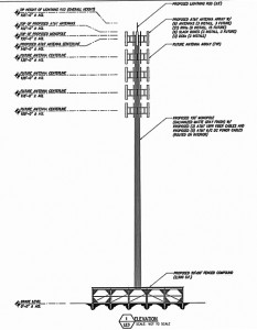
AT&T SCHEMATIC OF 155 FOOT MONOPOLE

AT&T SCHEMATIC OF 155 FOOT MONOPOLE

AT&T won no friends in Western Loudoun with its earlier shuffle on the topmost ridge of the Short Hill Mountain, shaving off trees and tunneling into the mountain, day and night, so secret, that almost everyone was convinced it was the “guv’ment” up to its old tricks, and the “data center” that AT&T claimed it was, had more to do with Mount Weather, the designated bunker for well placed elite government workers in the case of a nuclear attack, and that AT&T’s project was most certainly something other than a data center; the questions remain unresolved.

Emboldened by the local government’s seeming pliability, AT&T is now demanding a special exception to erect an 155 foot hi-tech shaft monopole on the crest, the very top, of the Short Hill Mountain.

The community is gathering its forces to give our public officials a spinal implant and to stop AT&T, on the merits, and based on the County Ordinance, from erecting this 155 foot monopole, and setting a bad precedent for projects on the crest of the mountain. Continue reading

What we’ve got

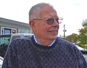
Eugene Scheel, map maker, at Bonnie’s

Eugene Scheel, map maker, at Bonnie’s

Maybe some don’t appreciate what we’ve got here in Western Loudoun because they just don’t know.

A fun way to cross that divide, and find out what we’ve got, is to get to know Eugene Scheel.

Eugene draws a line on fine paper to record an historic remnant, the ridge of a mountain, a creek or stream, a graveyard, a church, the place a plane crashed, and he does this with precision, and after much person to person historical research, gathering up the memories of eye witnesses, riding the local roads, and then memorializing the event and the date and the geographic spot where it all happened.

Gene, who is originally from Park Chester, in the Bronx, New York, has lived in Waterford, VA with his wife, Annette, since the 60s, and is best known these days as a mapmaker and historian par excellence.

Gene found he had a strong sense of location and direction walking the rolling ground and woods and rocky hillsides in training missions day and night for eight years as a corporal in the U.S. Marine reserves.

Gene “doodled” imaginary maps as a kid, and, after his service in the Marines, he really learned his craft from his tour of duty with the National Geographic Magazine, and his days at Rand McNally.

When he was a High School student, Gene wrote a letter to Dr. Gilbert Hovey Grosvenor, the first full time editor of National Geographic Magazine, and told Dr. Grosvenor that he liked to “doodle” imaginary countries and islands and was interested in making maps. Continue reading